Indonesia Implements Safety Steps in Anticipation of Possible Megathrust Earthquakes
Indonesia, positioned in the top 35 countries for natural disaster risk, is proactively gearing up for possible megathrust earthquakes that may lead to catastrophic tsunamis.
Indonesia, which ranks among the top 35 countries at risk for natural disasters, is in the process of gearing up for potential megathrust earthquakes that could unleash catastrophic tsunamis.
Dwikorita Karnawati, head of Indonesia's Meteorology, Climatology and Geophysics Agency (BMKG), highlighted that megathrust earthquakes are likely to occur in two specific zones: the Sunda Strait and the area surrounding the Mentawai-Siberut islands. These regions are recognized as seismic hotspots in the Indian Ocean, harboring significant seismic gaps that have persisted for hundreds of years.
"It is just a matter of time. Although we still cannot predict when the natural disaster will occur, we need to continue to talk about this issue so that people can be prepared for megathrusts," Karnawati stated to reporters.
A megathrust is defined as a massive earthquake occurring in a subduction zone, typically registering between 8 and 9 in magnitude.
Karnawati indicated that the BMKG has identified 13 zones in Indonesia with the highest likelihood of experiencing megathrust earthquakes. Four of the five largest islands—Java, Sumatra, Sulawesi, and Papua—are situated in these high-risk "red zones," each with a minimum potential magnitude of 7.8 on the Richter scale.
Indonesia’s susceptibility to earthquakes and megathrusts stems from its geographic position within the Pacific Ring of Fire, making it particularly vulnerable to seismic events.
The country has faced devastating seismic events in the past, such as the magnitude-9.3 earthquake that struck Aceh province in December 2004, leading to a massive tsunami. This disaster resulted in at least 220,000 fatalities and left over 800,000 people homeless, according to figures from the country's disaster mitigation authorities.
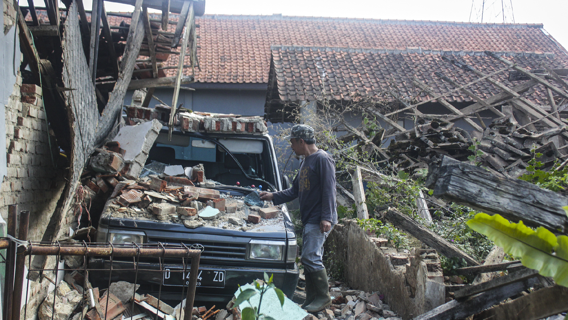
Recently, Indonesia recorded a series of earthquakes, including a magnitude-6.1 quake in Gorontalo province that damaged mosques and schools. Prior to that, Maluku province experienced a magnitude-4.6 earthquake.
BMKG data reveals that five significant earthquakes have occurred since September 1, affecting areas such as Gianyar in Bali, Bandung, and Garut regencies in West Java, in addition to those in Gorontalo and Maluku provinces.
In response, Indonesia's National Disaster Management Agency (BNPB) has initiated proactive measures to mitigate the potential impacts of megathrusts. These initiatives include the installation of numerous early warning sensors for tsunamis and verification of the functionality of communication systems.
Furthermore, the agency has ramped up awareness campaigns within local communities to educate residents on earthquake preparedness and the appropriate use of evacuation routes and tsunami shelters.
"BNPB, in collaboration with regional governments as well as police and military institutions, holds a simulation of what we should do when the megathrust disaster occurs and what the community needs to do when it happens," commented Lieutenant General Suharyanto, head of BNPB, on Tuesday.
While he expressed hope that a megathrust earthquake would not strike in the immediate future, he underscored the importance of remaining vigilant and well-prepared.
Sophie Wagner contributed to this report for TROIB News
Dwikorita Karnawati, head of Indonesia's Meteorology, Climatology and Geophysics Agency (BMKG), highlighted that megathrust earthquakes are likely to occur in two specific zones: the Sunda Strait and the area surrounding the Mentawai-Siberut islands. These regions are recognized as seismic hotspots in the Indian Ocean, harboring significant seismic gaps that have persisted for hundreds of years.
"It is just a matter of time. Although we still cannot predict when the natural disaster will occur, we need to continue to talk about this issue so that people can be prepared for megathrusts," Karnawati stated to reporters.
A megathrust is defined as a massive earthquake occurring in a subduction zone, typically registering between 8 and 9 in magnitude.
Karnawati indicated that the BMKG has identified 13 zones in Indonesia with the highest likelihood of experiencing megathrust earthquakes. Four of the five largest islands—Java, Sumatra, Sulawesi, and Papua—are situated in these high-risk "red zones," each with a minimum potential magnitude of 7.8 on the Richter scale.
Indonesia’s susceptibility to earthquakes and megathrusts stems from its geographic position within the Pacific Ring of Fire, making it particularly vulnerable to seismic events.
The country has faced devastating seismic events in the past, such as the magnitude-9.3 earthquake that struck Aceh province in December 2004, leading to a massive tsunami. This disaster resulted in at least 220,000 fatalities and left over 800,000 people homeless, according to figures from the country's disaster mitigation authorities.
Recently, Indonesia recorded a series of earthquakes, including a magnitude-6.1 quake in Gorontalo province that damaged mosques and schools. Prior to that, Maluku province experienced a magnitude-4.6 earthquake.
BMKG data reveals that five significant earthquakes have occurred since September 1, affecting areas such as Gianyar in Bali, Bandung, and Garut regencies in West Java, in addition to those in Gorontalo and Maluku provinces.
In response, Indonesia's National Disaster Management Agency (BNPB) has initiated proactive measures to mitigate the potential impacts of megathrusts. These initiatives include the installation of numerous early warning sensors for tsunamis and verification of the functionality of communication systems.
Furthermore, the agency has ramped up awareness campaigns within local communities to educate residents on earthquake preparedness and the appropriate use of evacuation routes and tsunami shelters.
"BNPB, in collaboration with regional governments as well as police and military institutions, holds a simulation of what we should do when the megathrust disaster occurs and what the community needs to do when it happens," commented Lieutenant General Suharyanto, head of BNPB, on Tuesday.
While he expressed hope that a megathrust earthquake would not strike in the immediate future, he underscored the importance of remaining vigilant and well-prepared.
Sophie Wagner contributed to this report for TROIB News
Find more stories on the environment and climate change on TROIB/Planet Health